

A Survey Is Not a Plan
A topographic survey is just elevation points, boundaries, and existing features. Turning it into drawings a contractor and a reviewing authority can both build from is where drafting does its work.
Every subdivision, gated community, or industrial park eventually needs the same translation: field data into buildable drawings. Land development drafting takes a topographic or GIS survey and layers plot boundaries, road networks, grading contours, drainage paths, and utility corridors on top of it — producing files a municipal reviewer, a contractor, and a utility company can all read the same way.
Skip a step in that translation and the result is rework: a road that doesn’t match the actual slope, a drainage line that conflicts with a sewer main, a plot boundary that’s off by a few feet once construction stakes go in.
Where Rework Usually Starts
What Goes Into a Land Development Plan
Three layers of drafting work sit on top of the base survey, each answering a different question a reviewer or contractor will ask.
Deliverable Comparison Matrix
Each deliverable in a land development package answers a different question, and gets checked against a different standard. Here’s how the core plan types compare.
| Plan Type | Primary Purpose | Key Elements | Format |
|---|---|---|---|
| Subdivision Layout | Defines buildable plots & access | Plot boundaries, ROW, setbacks, lot numbers | DWG / PDF |
| Grading & Drainage | Manages slope & stormwater | Cut/fill contours, swales, retention areas | DWG / PDF |
| Utility Layout | Routes underground services | Water, sewer, electric corridors, trench zones | DWG / GIS |
| Zoning Overlay | Confirms code compliance | Land use zones, buffers, setback lines | PDF / GIS |
| Site Plan | Single-parcel overview | Building footprint, parking, access points | DWG / PDF |
The Journey From Survey to Construction-Ready CAD
Every project moves through the same sequence of translations — usually across five structured phases, from raw field data to an approval-ready set.
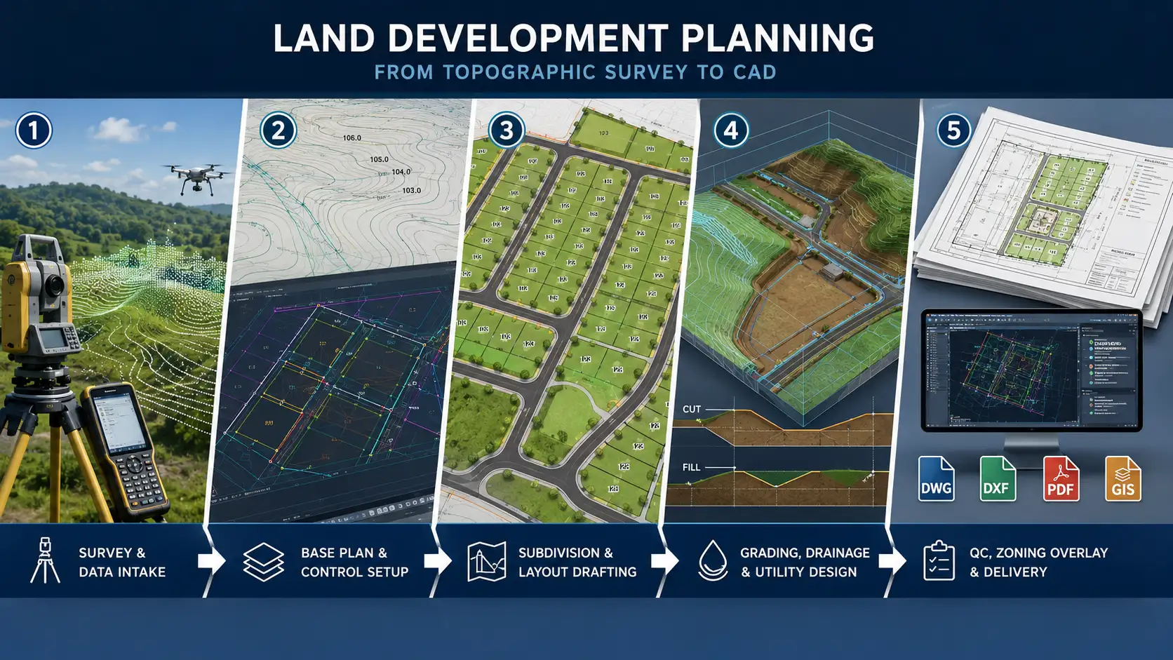
What a Land Development Package Looks Like
Hourly, per-sheet, or full-project pricing scoped to your development size, with transparent costs and no hidden charges.
Drafting Standards We Follow
Every layout is checked against the codes a local reviewing authority will actually apply — not a generic template.
Local Municipal DCRIS Codes — Drainage & SetbacksNational Building Code (NBC)BIS & IRC Compliance
Survey Data vs. Construction-Ready CAD
Raw Topographic Survey
- Elevation points and contours only, no plot boundaries
- No road hierarchy or lot numbering
- No drainage or utility routing
- Not checked against zoning or setback rules
- Unusable for approvals or construction staking
Construction-Ready CAD Plan
- Plot boundaries, area tables, and lot numbers
- Road hierarchy, ROW, and setbacks defined
- Grading, drainage, and utility corridors routed
- Zoning overlays and code compliance built in
- Approval-ready, layer-separated CAD deliverable
Who Relies on Land Development Drafting

Key Takeaways
The short version, if you’re scoping a project or briefing a team:
Where Survey Accuracy Actually Gets Tested
A grading plan built on stale or misread survey data doesn’t fail in the office — it fails on-site, once excavation starts and the real slope doesn’t match the drawing. That’s why cut/fill modeling and benchmark checks happen before a single plot line gets drawn.
From Survey Lines to a Site-Ready Plan
The distance between a topographic survey and a construction-ready plan is really a series of checks: does the layout respect the actual slope, does the drainage avoid the utility corridors, does every plot meet setback and zoning rules before it reaches a reviewing authority. Get that sequence right and the drawings hold up through approvals, bidding, and the actual dig. Microdras builds that sequence into every land development package, from the first utility routing pass to the final layer-separated CAD set.
Ready for a Plan That Clears Approvals?
Talk to our team about turning your survey into a subdivision, grading, and utility plan that clears approvals the first time.
Frequently Asked Questions
What drawings come with a land development package?
A full package covers subdivision and layout plans, grading and drainage drawings, zoning overlays, utility routing, and approval-ready CAD files in your required formats.
Can you draft directly from a topographic or GIS survey?
Yes. Survey or GIS base data is imported and checked against control points before any layout, grading, or utility work is drafted on top of it.
Do you handle plot-wise area calculation and numbering?
Each plot is dimensioned, numbered, and labeled with area in square meters or square feet, along with a summary area table for the full layout.
Are water, sewer, and electric lines included in the layout?
Yes, utility routing is drafted alongside the plot layout, including trench zones, road crossings, and access nodes where required.
Can you produce phased masterplans for larger developments?
Yes, phase-wise layouts are available for larger township or subdivision projects, including shared infrastructure and zoning buffers between phases.

